The European Union’s
Galileo Search and Rescue
Caralb News • April 7, 2017
AAs well as providing a civilian controlled accurate GNSS capability Galileo will help Search and Rescue crews respond to distress signals faster and more effectively while also lowering their own exposure to risk.
The Galileo programme is Europe’s global navigation satellite system (GNSS), providing a highly accurate global positioning service under civilian control. The fully deployed system will consist of 24 satellites and 6 active spares in orbit, and its associated ground infrastructure. Galileo provides Europe with independence in satellite navigation but also interoperability with other global navigation satellite systems.
Galileo offers more accurate positioning, thanks to a greater number of signals, a new satellite clock design, and improved corrections of ionospheric effects. In combination with GPS signals, this will allow positioning within a metre, depending on the service used.
SAR CAPABILITIES
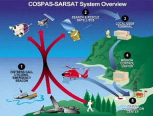
Galileo’s SAR capabilities are integrated into the international COSPAS-SARSAT programme – a satellite-based SAR distress alert detection and information distribution system. With Galileo, SAR localisation is down to 10 minutes and 2 km from up to 4h and 10km.
COSPAS-SARSAT detects and locates emergency beacons activated by aircraft, ships and individuals. It provides accurate, reliable, and timely alert and location data to help SAR crews find and help people in distress.
Galileo plays an important role in the Medium Earth Orbit Search and Rescue system of COSPAS-SARSAT (MEOSAR), and provides a ground segment coverage of 40 million square km over Europe as a contribution to the MEOSAR global coverage.
The Search and Rescue transponders on Galileo satellites can pick up signals emitted from any 406MHz (EPIRB) distress beacon anywhere in the service coverage area and transmit this information to the dedicated ground stations (MEOLUTs).
Once the beacon is located by the MEOLUTs, this location data is sent to the COSPAS-SARSAT mission control centre (MCC), which distributes it to the relevant rescue centres. The rescue centres, under the responsibility of national competent authorities and administrations, then coordinate the required rescue efforts.
Thanks to the advanced European technology used, integration of Galileo into COSPAS-SARSAT improves the system by:
By the end of 2018, people in distress will also receive an acknowledgment via the Galileo SAR Return Link Service that their distress signal has been received and localised and that help is on the way.
The SAR/Galileo infrastructure is interoperable with GPS and GLONASS SAR transponders.
With Galileo, the time to identify the location of a beacon signal is reduced from several hours to a few minutes. At sea, this makes SAR rescue operations easier thanks to a narrowed ‘search box’, since the vessel in distress has less time to drift. It also brings great improvements to land based distress response and it enhances location of an aeroplane in distress, which will be mandatory from 1st January 2021.
The SAR service represented just 1% of total Galileo programme costs, but the EU claims it should result in thousands of lives being saved.
ADDITIONAL EFFICIENCIES
The Galileo SAR service officially started operations in December 2016 when the Initial Services were declared, but with the planned launch of additional satellites to reach 30 operational units in space, Galileo SAR will become even more efficient and more reactive.
To provide beacon identification and location information, the satellite downlinks are processed by ground receiving stations called MEO Local User Terminals (MEOLUT). The distress alert information computed by MEOLUTs is forwarded to COSPASSARSAT Mission Control Centres (MCCs) for distribution to SAR services. The MEOSAR payloads are designed according to interoperability requirements, which allow the MEOLUTs to compute the location of distress beacons based on any combination of signals received from the MEOSAR satellites.
BEACON DEVELOPMENTS
PLB Personal Locator Beacons (PLBs) are generally carried by individuals, away from normal emergency services or on ships and airplanes, but are sometimes integrated into personal marine safety equipment. They are activated manually by pressing a button and operate on 406MHz. PLBs are small, not much larger than a mobile phone, have a medium battery life and are registered to a person.
EPIRB Emergency Position Indicating Radio Beacons (EPIRBs) are installed on marine vessels. They are activated when in contact with water if the boat is sinking. Deployment can also happen manually, when the EPIRB is physically removed from its bracket, or automatically when water pressure triggers a hydrostatic release unit to release the EPIRB from its bracket.
The new SAR service will be provided free of charge to those with the necessary beacon technology to access it. It is anticipated that a new generation of beacons will begin to appear to leverage the development, especially containing the necessary equipment to display the all-important return confirmation message when the Galileo Return Link Service goes on stream at the end of next year.
By Jake Frith
See more at: Maritime Journal